
Atlantis Legacy
ATLANTIS LEGACY
‘Head and shoulders the best read of the year’ Wreckwatch Magazine


I’m delighted to announce the publication of my eleventh Jack Howard novel, Atlantis Legacy. The English language editions of the novel are available at present exclusively on Amazon as an ebook and a large format paperback. You can buy it on Amazon.co.uk, Amazon.com and other Amazon sites, where you can read a preview of the first three chapters. The French edition, L’Héritage d’Atlantis, was published in hardback and ebook by Les Escales in September 2023 and in a Pocket edition in November 2024, and is available both online and in bookshops. On this page you’ll find images related to the novel and its archaeological and historical backdrop. I hope you enjoy it!
The book has had many five star reviews on Amazon and elsewhere.
Egypt, 1334 BC In a horrifying ritual never before performed, a pharaoh is mummified alive for rejecting the old gods and thinking that he holds the key to immortality. Unknown to his tormentors, he had hidden away a secret brought to Egypt thousands of years before by the survivors of a lost civilisation …
England, AD 1667 A richly laden merchantman is wrecked on the coast of Cornwall in one of worst storms in memory. On board is a treasure map like no other, found in Rome and rescued from the ship by the captain - only for it to be lost again in one of the most forbidding places on earth.
Present-day Marine archaeologist Jack Howard and his friend Costas are on the trail of an extraordinary mystery - one that takes them from a shipwreck off England and a terrifying dive in a submerged mine to the underground ruins of Rome and a remote island in the Atlantic, in the hunt for ancient knowledge that might benefit all of humanity.
ATLANTIS LEGACY is a thriller grounded in real-life archaeology and plausible scenarios - the hallmarks of an author whose own discoveries as an archaeologist and diver have provided the basis for twelve novels that have sold over three million copies and been published in 30 languages.
Click here to see my page on all of the Jack Howard novels.


Review of Atlantis Legacy in Wreckwatch Magazine.
On my previous novels:
On PHARAOH: '... utterly absorbing ... a superb novel ... put aside your assumptions of what a thriller should be an instead immerse yourself in one of the best historical adventures you'll read this year.' For Winter Nights
'I find every single one of these books so plausible, so real I hate coming up for air ... a true leader of his genre and his art.' Parmenion Books
On PYRAMID: '... an utterly compelling historical adventure thriller, delivered by a man who lives and breathes the archaeology' Parmenion Books
On THE SWORD OF ATTILA: 'A hugely entertaining novel, thoroughly researched and vividly characterised.' Historia
On DESTROY CARTHAGE: 'Superb scenes of the horrid surprises of war ... the road to that Roman victory is the true reading enjoyment' Kirkus Reviews
' ... simply breathtaking ... one of the best historical novels of the year' Upcoming4.me
On TESTAMENT: 'A brilliantly written thriller' Parmenion Books
'The diving sequences are marvellous ... there isn't another thriller hero like Jack Howard and I treasure him' For Winter Nights
On INQUISITION: ‘A sophisticated plot lifts bestseller Gibbins’s superior 10th thriller featuring archeologist Jack Howard … fans eager for an intelligent blend of suspense and reality, including some horrific contemporary developments, will be rewarded.’ Starred review, Publishers Weekly
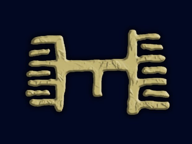
The ‘Atlantis symbol’ - an actual symbol on the Phaestos Disc, a pottery disk with many undeciphered symbols found in the Minoan palace of Phaestos in Crete and thought to date from the Bronze Age, though it may be earlier (artwork: Alan Gibbins).


Click on the images to enlarge:
Athanasius Kircher’s map of Atlantis from Mundus Subterraneus (1665), based on ‘Egyptian sources and Plato’s description.’ As was a Dutch cartographic convention at the time, the view is looking south - with Europe and Africa to the left and the Americas to the right.
Another map showing Atlantis in a work by Athanasius Kircher, his Arca Noë, in tres libros digesta, quorum I. De rebus quæ ante diluvium, II. De iis, quæ ipso diluvio ejusque duratione, III. De iis, quæ post diluvium a Noëmo gesta sunt, quæ omnia novâ methodo, nec non summa argumentorum varietate, explicantur, et demonstrantur. This map, published in 1675, shows a smaller Atlantis - though still implausibly large - closer to the Americas than his earlier, more detailed map of 1665.
In the novel, Jack goes in his inflatable kayak from Mullion harbour to the wreck of the Santo Cristo di Castello - the Mullion Pin Wreck - off the west coast of the Lizard Peninsula in Cornwall. This shows me doing exactly the same, in conditions of exceptional calm and underwater visibility during the summer (photo: David Gibbins).
My kayak and rig ready to be put on for a dive to the Mullion ‘Pin Wreck’, just as Jack does in the novel (photo: David Gibbins).
The Church of St Winwaloe, the ‘Church of the Storms’, at Gunwalloe on the west side of the Lizard Peninsula in Cornwall, nestled behind the promontory between Church Cove and the cove of Jangye-ryn. Most of the present building dates from the 15th century but a church has been here since as early as the 5th century. It is here that Jack meets members of an ancient brethren to be let into the tower to be shown a remarkable secret (photo: David Gibbins).
One of two sets of paintings in Gunwalloe church on panels that were once part of the rood screen, probably dating to the 16th century. In my novel Jack is able to confirm a long-held belief that these were Portuguese and salvaged from the nearby wreck of the St Anthony, a richly laden ship that sank in 1527 (photo: David Gibbins).
Another view of the church at Gunwalloe, showing the tower built into the side of the headland - a promontory fort in Iron Age times but with at least one barrow of the Bronze Age on top as well (photo: David Gibbins).
The interior of the tower at the church at Gunwalloe, showing where the medieval masonry abuts the bedrock - with pick marks visible on the rock. It is possible that this rock-cut chamber is the site of the original monastic cell thought to have been here from the 5th century. In my novel Jack is led into fictional space beyond this rock wall (photo: David Gibbins).
The engine house of West Wheal Owles, part of the extensive mine ‘sett’ at Botallack on the west coast of Cornwall. This was the main inspiration for the fictional mine in my novel and was also one of the locations used in filming the BBC drama Poldark (photo: David Gibbins).
A view looking north of the Botallack mine, showing West Wheal Oates to the right and other mine workings (photo: David Gibbins).
The pumping shaft in front of West Wheal Oates. The shafts dropped over 200 fathoms - 600 feet - and the levels extended more than half a mile out under the sea, including inclining shafts such as the one I describe in my novel. West Wheal Owles was the scene of a disaster in 1893 when the mine flooded and 19 men were drowned; their bodies were never recovered (photo: David Gibbins).
A level of the mine at Botallack, showing the walls cut by the miners as they chased the lode of tin-bearing ore (photo: David Gibbins).
The Bembine Tablet, as recorded by Athanasias Kircher and published in his Oedipus Aegyptiacus (1656). Thought by many scholars to be a Roman creation based on Egyptian imagery, it was acquired by Cardinal Bembo after the sack of Rome in 1527 by soldiers of the Holy Roman Empire and is today in the Egypt Museum in Turin.
The ‘Battlefield Palette’ - the lower part in the British Museum and the upper a cast of a fragment in the Ashmolean Museum, Oxford. Dating from the 4th millennium BC and showing scenes of the aftermath of battle, it is one of the oldest works of art from Egypt and is the basis for the fictional fragments found near Lake Bardawil in my novel. Width 28.7 cm (EA20791, © The Trustees of the British Museum).
The ‘Pitt-Rivers Knife’, one of a number of beautifully flaked flint knifes from 4th millennium BC Egypt. Could they have been used for embalming or an early form of mummification, as I suggest in my novel? (EA68515, © The Trustees of the British Museum).
New Zealand Mounted Riflemen on the salt pans of Sabkahat Bardawil, Egypt, 1916 (Powles family :Photographs. Ref: 1/2-178616-F. Alexander Turnbull Library, Wellington, New Zealand. /records/22913335). The photo is thought to have been taken by Lieutenant Colonel C.G. Powles, whose book The History of the Canterbury Mounted Rifles 1914-1919 gave me the idea of locating a site from early prehistory beside the lake where the New Zealand soldiers had dug a canal to the sea in May 1916.
My brother Alan created the cover image for the novel from this photo I took of him on the Charles P. Minch, a schooner sunk in 1898 near Tobermory on Lake Huron and one of our favourite dive sites (photo: David Gibbins).